Ireland from the best authorities 1794 Wilkinson scarce map
Brian DiMambro- Antiquarian Books, Maps & Prints
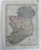
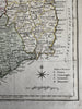
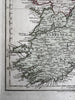
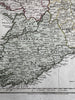
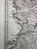
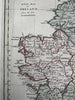
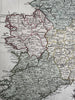
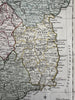
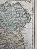
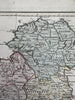
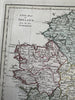
A new map of Ireland from the best authorities.
Issued London, 1794 by Wilkinson.
Uncommon late-18th century engraved map with original hand color.
A beautiful map of this island.
Clean, fine condition.
Sheet measures c. 10 1/2” x 13 1/8”.
Printed area c. 8 3/4" x 11 1/4".
R36271