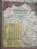
Maryland & Delaware states 1855 Cowperthwait map county slave population shown
Brian DiMambro- Antiquarian Books, Maps & Prints
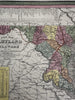
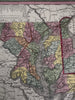
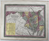
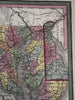
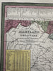
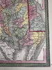
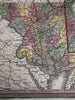
A New Map of Maryland and Delaware with their canals, roads & distances.
Published 1850-55, Phila. by Thomas, Cowperthwait & Co. (This variant issue likely being 1854-5 despite the imprint at bottom stating 1850). There are several variants of this map which all display the same 1850 imprint but were released across years within atlases having later title page dates.
Fascinating mid- 19th century (engraved) lithographed map with original hand color.
Steam boat routes key across top, Large Population census box in yellow lower left noting the number of slaves county by county for a grand total of 90,368 within Maryland..
Well printed and colored folio sheet map, perfect for display, gift giving, being part of a collection, etc. Of real historical note for contemporary accounting of slavery on a state map.
Clean, fresh, near fine condition.
Sheet measures c. 16 7/8” x 13 1/2”.
Printed area c. 14 5/8" x 11 1/2".
R36429