United States Republic Texas Oregon Missouri Indian Territory 1839 Mitchell map
Brian DiMambro- Antiquarian Books, Maps & Prints

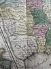
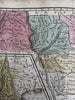
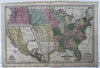


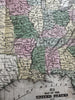


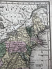

Map of the United States and Texas.
Issued 1839, Connecticut by SA Mitchell. Engraved by W. Williams.
Great early 19th century engraved map of the United States with original hand color.
VG condition, light age spotting, short closed split at base of centerfold, overall presents well, nice looking example.
Of note for the depiction of Texas as an independent Republic, prior to statehood.
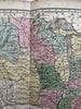
Inset of Mexico & Central America at bottom left.
Huge Oregon Territory extends up into modern day British Columbia Canada. Large territories of Missouri, Indian, Iowa and Wisconsin, all short-lived configurations as seen here together.
Sheet measures c. 11 3/4” x 17 3/4”
Printed area c. 10 3/8” x 16 1/4”.
R36293