Western United States Michigan Wisconsin Territory IL IN MO KY 1839 Mitchell map
Western United States Michigan Wisconsin Territory IL IN MO KY 1839 Mitchell map Western United States Michigan Wisconsin Territory IL IN MO KY 1839 Mitchell map Western United States Michigan Wisconsin Territory IL IN MO KY 1839 Mitchell map Western United States Michigan Wisconsin Territory IL IN MO KY 1839 Mitchell map Western United States Michigan Wisconsin Territory IL IN MO KY 1839 Mitchell map Western United States Michigan Wisconsin Territory IL IN MO KY 1839 Mitchell map Western United States Michigan Wisconsin Territory IL IN MO KY 1839 Mitchell map Western United States Michigan Wisconsin Territory IL IN MO KY 1839 Mitchell map Western United States Michigan Wisconsin Territory IL IN MO KY 1839 Mitchell map Western United States Michigan Wisconsin Territory IL IN MO KY 1839 Mitchell map Western United States Michigan Wisconsin Territory IL IN MO KY 1839 Mitchell map Western United States Michigan Wisconsin Territory IL IN MO KY 1839 Mitchell map Western United States Michigan Wisconsin Territory IL IN MO KY 1839 Mitchell map Western United States Michigan Wisconsin Territory IL IN MO KY 1839 Mitchell map Western United States Michigan Wisconsin Territory IL IN MO KY 1839 Mitchell map
$ 125.00

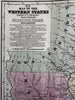
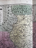
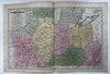
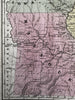
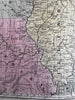
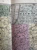
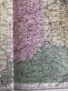
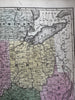
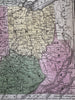
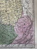
Map of the Western States.

Issued 1839, Connecticut by SA Mitchell. 

Great early 19th century engraved map of the then “ western” United States with original hand color.

Names Wisconsin & Iowa territories. Early depiction of numerous counties, lacking some modern counties as well.

VG condition, light age spotting, overall presents well, nice looking example.

Sheet measures c. 11 3/4” x 17 3/4”

Printed area c. 10 3/8” x 16 1/4”.

R36295