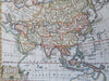
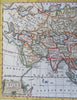
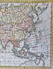
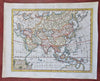
Asia Japan Qing China Mughal India Indonesia Arabia Ottomans 1772 Jefferys map
Brian DiMambro
Asia.
(Old Maps, 18th Century Maps, Asia, Ottoman Empire, Persia, Iran, Russian Empire, Mughal India, Qing China, Japan, Korea, Philippines, Southeast Asia, Indonesia).
Issued 1772, London. Engraved by Jefferys.
Late 18th century engraved map with attractive hand color. Vignette title at lower left.
Remains a nice looking example with a pleasing age patina. Any age flaws mostly minor and easy to overlook or forgive.
Original fold lines as issues.
Sheet Measures c. 8 1/2" H x 10 1/4" W.
Engraved Area Measures c. 7" H x 9" W.
Cartographic Reference(s):
Tooley's Dictionary of Mapmakers, vol. 3.
[B12375].