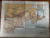
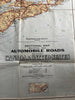
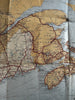
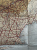
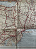
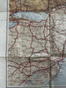
early main Automobile Roads 1929 Canada & America NRIS rare wall map Atlantic
Brian DiMambro- Antiquarian Books, Maps & Prints


separately issued mid-20th century color lithographed. map.
Folio sheet map, issued by Department of the Interior- Canada. Sectional Map Indicating main Automotive Roads between Canada & United States. (Atlantic Sheet). 1929.
Scarce large oversize map. Wall map size. Sheet measuring c. 30" H x 40" W.
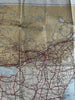
Sheet shows various small signs of time and handling such as a couple short edge splits, 2” split at bottom left blank margin fold line, other small splits at fold line intersections, right edge slightly ragged and toned, small scattered age spots or light discolorations all of which should be captured quite well by the pictures provided.
Please inspect pictures, they represent this rare map better than a verbal description.
Scarce. Worthy of display as it survives. Map was likely intended to be displayed in public.
B15059
Folded long ago, acquired folded, will be shipped folded.