Newfoundland Fishing Banks Halibut Cod Great Bank c. 1890's nautical map
Brian DiMambro
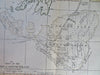
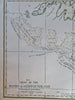
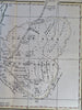
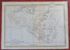
Chart of the Banks of Newfoundland.
(Old Maps, 19th Century Maps, Canada, Newfoundland, Fishing Banks, Halibut, Cod, Nautical Maps).
Issued c. 1890's (?), United States.
Uncommon late 19th century (?) lithographed map with lovely hand color.
Original fold line as issued. Closed tear from bottom right edge (easy to overlook or miss), some old pencil lines (erasable) on reverse, map displays well and is priced to reflect any flaws.
Sheet Measures c. 10 3/4" H x 15" W.
Printed Area Measures c. 9 1/2" H x 13 3/4" W.
[R32232].