Scotland hotels picture map Scottish Vacation 1914 Caledonia Railway Co. guide
Brian DiMambro- Antiquarian Books, Maps & Prints

(Old Books, Early 20th Century Books, Travel, Tourism, United Kingdom, Scotland, Illustrated Books, Promotional Guides, Books with Maps).
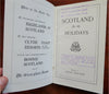
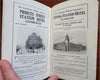
Scotland for the Holidays, by George Eyre-Todd.
Published 1914, United Kingdom by Caledonia Railway Company.
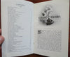
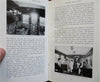
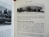
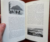
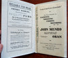
156 pages plus wrapper covers. Text in English. Illustrated throughout. Abundant period advertising.
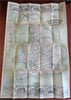
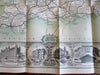
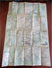
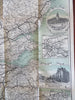
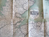
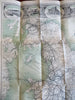
With a spectacular large folding color lithographed map at rear which has a series of grand hotel vignettes across the top and bottom. Printed on both sides, the second large map also has vignettes.
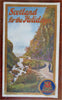
Publisher's color pictorial paper wrappers.
Item is over 100 years old and shows some signs of handling and time. Item is not new or in "new" condition.
Paper covers age worn, slight rubbing, remains overall clean and attractive as a fragile survival.
Text block paper is toned, signs of handling, small scattered spotting, internally still well preserved, tight, sound.
Still attractive on the shelf. The scarce pamphlet displays a pleasing and unique age patina and is in nice antiquarian condition, any age flaws easy to overlook or forgive.
Please review photos for more detail and our best attempt to convey how this antique guide book and loose map survives.
Covers measures c. 8 1/4" H x 5" W.
Large folding map measures c. 20" W x 30" H.
[B4806].