Boston Massachusetts pocket maps c. 1890 Damrell & Upton pair lovely scarce
Brian DiMambro- Antiquarian Books, Maps & Prints


[19th century pocket Maps, Americana, United States, New England, Massachusetts, Boston, Detailed City Plan].
Short video captures condition much better than words. Please watch prior to purchase to ensure a clear understanding of the book.
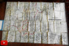
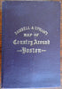
Damrell & Upham's Map of Country Around Boston.
Published 1889, Boston by Damrell & Upton; small map c. 1890, New York by The Metropolis Map Company.
2 lithographed folding maps printed on bond paper, largest one with original hand color.
Publisher's cloth binding, cover gilt lettered.
Large hand colored map clean, displays some splitting along bottom horizontal fold line (clearly shown in video). Smaller map with minor splits at some fold line intersections. Any age flaws are easy to overlook or forgive.
Rare item from relatively small publishers.
Book measures: 5 3/4" H X 4" W.
[V2355].