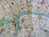
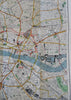
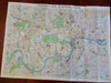
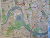
Central London c. 1937 Large Folding Map Tourism Travel
Brian DiMambro- Antiquarian Books, Maps & Prints


(Old Maps, 20th Century Maps, United Kingdom, England, London, City Plans, Travel, Tourism).
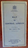
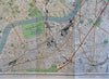
Map of Central London
Published c. 1937, London by Edward Stanford LTD.
Folding map. Text in English. Unfolds to large city plan of central London and environs.
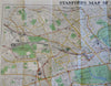
Publisher's pictorial paper wrappers folded into panels, printed on both sides.
Item is old and shows some signs of handling and time. Item is not new or in "new" condition.
Paper gently age worn, slight rubbing, remains overall clean and attractive as a fragile survival.
Paper is lightly toned, signs of handling, small scattered spotting, internally still well preserved, tight, sound.
Still attractive on the shelf. The scarce pamphlet displays a pleasing and unique age patina and is in nice antiquarian condition, any age flaws easy to overlook or forgive.
Please review photos for more detail and our best attempt to convey how this large detailed map survives.
Covers measures c. 9" H x 5" W.
Map measures c. 27 1/4" H x 34 1/2" W.
[B6488].