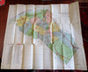
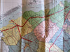
Gloucester County New Jersey 1944 detailed folding large color county map
Brian DiMambro- Antiquarian Books, Maps & Prints
(Old Maps, North America, United States, New Jersey, Gloucester County, Highways, County Map, Folding Maps).
Map of Gloucester County New Jersey, Showing State and County Highways and Boundaries of Townships and Municipalities.
Published 1944, United States by Gloucester County Board of Chosen Freeholders.
Folding color lithographed map. Text in English.
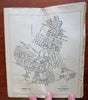
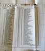
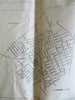
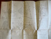
Publisher's large folded single sheet map, printed on both sides. One side is color county map, other side is a series of numerous smaller detailed city plans.
Item is physically old and shows some signs of handling and time. Item is not new or in "new" condition.
Paper gently age worn, slight rubbing and age staining, some short splitting along fold lines at intersections, remains overall clean and attractive as an object.
Text block paper is gently toned, signs of handling, internally still well preserved, tight, sound.
Still attractive on the shelf. The fragile large map displays a pleasing and unique age patina and is in nice antiquarian condition, any age flaws easy to overlook or forgive.
Please review photos for more detail and our best attempt to convey how this WWII era map survives.
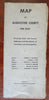
Covers measures c. 10" H x 4 1/2" W.
[B3676].