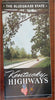
Kentucky Highway Road Atlas WWII Era Travel Brochure c. 1939-43 illustrated book
Brian DiMambro- Antiquarian Books, Maps & Prints


(Old Books, 20th Century Books, Americana, Kentucky, Travel, Tourism, Highway Maps, Illustrated Books).
Kentucky Highways.
Published c. 1939-43, United States.
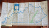
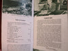
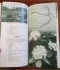
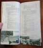
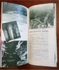
63 [64] pages plus wrapper covers. Text in English. Illustrated throughout. A large folding state map at rear.
Publisher's pictorial photographic paper wrappers.
Item is old and shows some signs of handling and time. Item is not new or in "new" condition.
Paper gently age worn, minor signs of handling, slight rubbing, remains overall clean and attractive as a fragile survival.
Still attractive on the shelf. The scarce pamphlet displays a pleasing and unique age patina and is in nice antiquarian condition, any age flaws easy to overlook or forgive.
Please review photos for more detail and our best attempt to convey how this item survives.
Covers measures c. 10" H x 4 3/4" W.
[B5360].