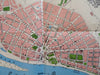
Kostroma Russia in 1913 Pictorial Historical Map 2000 City Plan & Views
Brian DiMambro- Antiquarian Books, Maps & Prints
(Old Maps, 20th Century Maps, Historical Maps, Russian Empire, Kostroma, City Plan, Architectural Views).
City Plan of Kostroma in 1913.
Published 2000, Moscow by Community of St. Euginia & the Red Cross.
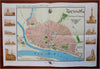
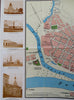
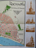
Folding map. Text in Russia. Pictorial architectural views on either side of map
Publisher's pictorial paper wrappers folded into panels, printed on both sides.
Item shows some signs of handling and time. Item is not new or in "new" condition.
Paper gently age worn, slight rubbing, remains overall clean and attractive as a fragile survival.
Paper is lightly toned, signs of handling, small scattered spotting, internally still well preserved, tight, sound.
Still attractive on the shelf. The scarce item displays a pleasing and unique age patina and overall is in nice antiquarian condition, any age flaws easy to overlook or forgive.
Please review photos for more detail and our best attempt to convey how this offering survives.
Map measures c. 11 3/4" H x 17 1/2" W.
[B8877].