Australia New South Wales Queensland West Australia 1872 Kuijper detailed map
Brian DiMambro
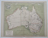
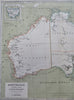
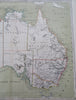
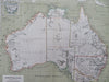
Australie. Eerste Blad Nieuw-Holland. Ontworpen en Geteekend door J. Kuijper.
(Old Maps, 19th Century Maps, Oceania, Australia, New South Wales, Queensland, West Australia, Sydney, Melbourne, Perth, Adelaide).
Issued 1872, Amsterdam by Kuijper & C.F. Stemler. Lithographed by Tresling & Co..
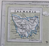
Very uncommon mid-19th century color lithographed map with original outline hand color. Includes inset map of Tasmania.
Original center fold as issued.
Sheet Measures c. 13 1/2" H x 17 3/8" W.
Engraved Area Measures c. 12 3/4" H x 15 1/2" W.
,
Cartographic Reference(s):
Tooley's Dictionary of Mapmakers, vol. 3.
Tooley, Mapping of Australia, not mentioned.
[R35748].