Australia NSW Queensland Coastal Chart 1774 Capt. Cook & Hawkesworth map
Brian DiMambro- Antiquarian Books, Maps & Prints
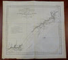


Carte d'une Partie de la Cote de la Nle. Galles Meridle. Depuis Le Cap Tribulation Jusqu'au Detroit de L'Endeavour par le Lieut. J. Cook - 1770.
(Old Maps, 18th Century Maps, Oceania, Australia, Queensland, Cape York, Cape Tribulation, Coastal Map, Cook Expedition).
Issued 1774, Paris by Hawkesworth. Map by Benard.
Nice 18th century engraved map based on the version which appeared in London a year prior to this Paris version. Tracks of Capt. Cook are visible with sounding depths, west is towards the top of the map. Shows where Cook's ship hit a reef that's part of the Great Barrier Reef.
Nice looking example, pleasing age patina, light old spotting along the blank margins, any minor age flaws easy to overlook or forgive.
Original fold lines as issued.
Sheet measures c. 13 3/8" H x 14 1/4" W.
Engraved area measures c. 10 3/4" H x 10 3/4" W.
Cartographic Reference(s):.
Tooley's Dictionary of Mapmakers, vol. 2.
[R29226].