Canada Maritimes & Newfoundland Nova Scotia New Brunswick c. 1890's Johnson map
Brian DiMambro- Antiquarian Books, Maps & Prints
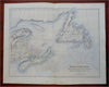
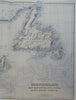

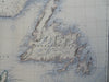

Newfoundland, New Brunswick, Nova Scotia, Prince Edward Island.
(Old Maps, North America, Canada, Maritimes, New Brunswick, Nova Scotia, Prince Edward Island, Newfoundland).
Issued c. 1890's, Edinburgh by A. Fullarton. Map by J. Hugh Johnson.
Late 19th century engraved map with original hand color.
Well preserved, nice looking example with pleasing age patina.
Original center fold as issued.
Sheet Measures c. 18 1/2" H x 23" W.
Engraved Area Measures c. 15 3/4" H x 20" W.
Cartographic Reference(s):
Tooley's Dictionary of Mapmakers, vol. 2.
[R28292].