Chile Coastal Harbor Survey 1748 Anson Inchin island engraved map
Brian DiMambro- Antiquarian Books, Maps & Prints
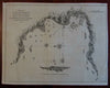

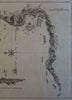
Plan of a Bay and Harbour on the Coast of Chili :Discovered by a Victualler to Commodore Anson's Squadron in the South Sea, 1741.
(South America, Chile, Commodore Anson, mid-18th Century Exploration)
Issued London, c. 1748 for Comm. Anson Voyage Round the the World. Engraved by R. W. Seale.
Important and interesting mid-18th century antique engraved map.
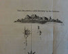
Among the first printed charts of factual on hand accuracy for this South American coastal location by the British, with sounding depths and ship tracks shown. Compass rose topped by fleur-de-lys orients north to the left.
Light surface toning as typical, some minor scattered spots, slight browning along couple fold lines, several small minor old paper edge repairs along top edge on back, overall the map is clean, well preserved and very attractive.
Original fold lines as issued.
Sheet measures c. 14" x 11"
Engraved area measures c. 13 1/2" x 10 1/4"
[R20862]
Tooley's Dictionary of Mapmakers, v. 4, p. 139.