Chinese Empire w/ Peking city plan Canton Japan Asia 1873 antique Meyer map
Brian DiMambro -Historical Investments
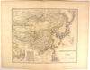
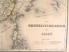

Das Chinesische Reich und Japan
(The Chinese Empire and Japan- Peking City Plan- Canton)
Published 1873, Hildburghausen, Germany by the Bibliographischen Institut
Original antique engraved German
map with printed color. Place names in German as always.
With a detailed inset plan of Peking at bottom center beside another inset showing Canton / Macao coastal area.
A detailed, scarce and interesting mid-19th century German map which could readily be collected on it's own merits, displayed or given as a present.
In VG antiquarian condition, mostly clean overall, light minor age dustiness or trivial small scattered age spotting as seen, short closed split at bottom centerfold in blank margin, original fold-line as issued, overall the map remains clean and attractive.
Please inspect photos closely- any noteworthy flaws to the printed surface area should be noticeable within pictures provided. These pictures form a central part of the item description and we encourage you to study them carefully. We will send the actual antique item shown.
[ note: We grade very conservatively. We are doing our best to show & describe this item so you are happy when it arrives ].
An interesting antique printed map that any collector, dealer, institution or person of taste would be happy to own or display.
Sheet measures c. 18 7/8" W x 14 5/8" H.
Engraved area measures c. 14" W x 11 1/2" H.
[R5234]