Delhi India detailed city plan by Weller c.1863 scarce old antique city plan
Brian DiMambro -Historical Investments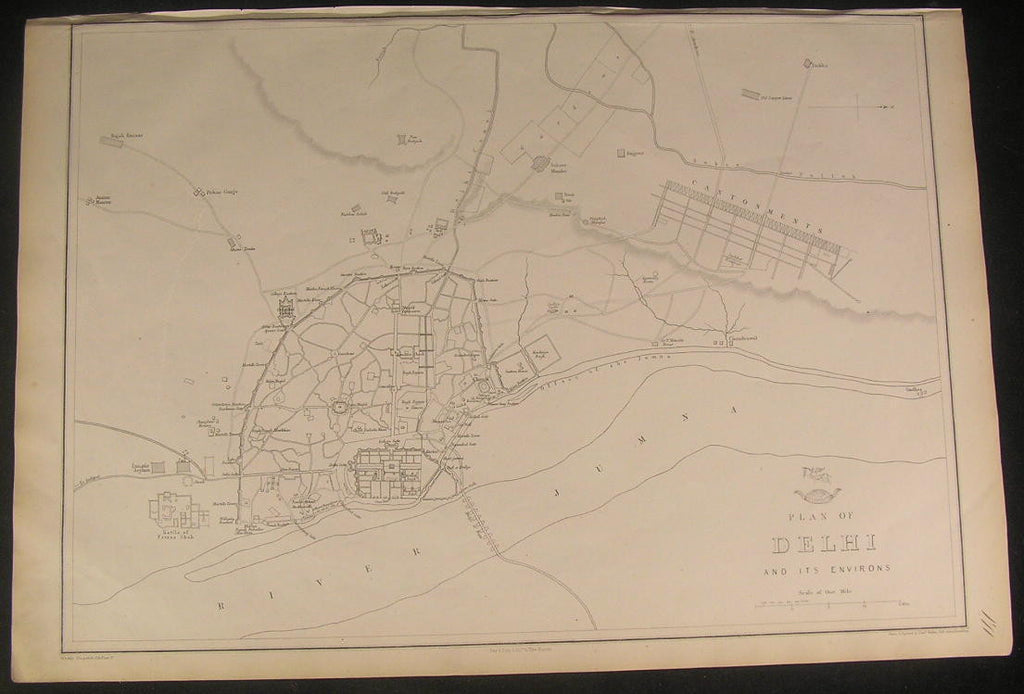


Plan of Delhi and its Environs
(India, Palace, Cantonments, River Jumna, Bridge of Boats, Lunatic Asylun)
Issued c.1863, by The Weekly Dispatch.
Engraved by Edward Weller
Detailed old lithographed city plan.
A picture is worth a thousand words. The photos are a major part of the item description. Please examine them closely, as what you see is what we will send you.
[note: we grade conservatively and always seek to disclose any noteworthy flaws.].
Map remains well preserved, but shows some signs of usage and age. Top blank margin is narrow but sufficient for framing. Some light age wear or surface spotting/ soiling which is visible within the scan, light scattered wrinkling, light dustiness, smudging, gentle toning, etc. The map still remains mostly clean & attractive visually, entirely worthy of ownership.
Paper and image remains overall clean & sound. Old maps & prints often display small minor repairs on the back, could have uneven blank margins, might have extraneous fold-lines or other small minor age flaws which do not detract from the visual appeal or value. Condition is carefully considered in arriving at our price.
Great old vintage antique map entirely worthy of hanging for display.
A cartographic depiction captured in a manner entirely unique to this era.
Sheet measures c. 13 1/4" H x 19 1/4" W.
Printed area measures c. 12 3/8" H x 17 3/8" W
Tooleys Dictionary of Mapmakers , v. 4, p.367
[R2886]