East Africa Coast of Adel Red Sea Nubia Arabia 1683 old Mallet map hand color
Brian DiMambro- Antiquarian
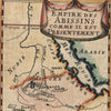
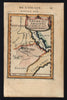
Empire des Abissins Comme il est Presentment.
(Africa- East- Abyssinia- Red Sea- Adel- Nubia)
Issued Paris, 1686 for A.M. Mallet.
Charming late 17th century copper engraved map, with pleasing full hand color.
The image has a near folk-art feel, a style unique to this historical era. Utterly unlike anything produced today and of modern aesthetic appeal for this reason.
Mostly clean and well preserved example, the image displays a fine patina.
Sheet measures c. 8 1/4"H x 5 1/8"W.
Printed area measures c. 5 5/8"H x 4"W.
Tooley's Dictionary of Mapmakers , v. 3. p.196
[R15005]