Geldern Westphalia Germany Holy Roman Empire c. 1630 lovely engraved city plan
Brian DiMambro
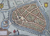

Gelria.
(Old Maps, 17th Century Maps, Europe, Holy Roman Empire, Westphalia, Geldern, City Plan, Decorative Maps).
Issued c. 1620-50, Europe. Possibly for Guicciardini by Blaeu.
Great little mid 17th century engraved map with attractive hand color.
Remains a nice looking example with a pleasing age patina. Any age flaws mostly minor and easy to overlook or forgive.
Sheet Measures c. 7 3/4" H x 11 3/4" W.
Engraved Area Measures c. 6 1/4" H x 9 1/2" W.
[R33683].