Grand Tartary Eastern Asia Mongolia Siberia Turkestan Korea 1683 Mallet map
Brian DiMambro
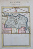
Grande Tartarie.
(Old Maps, 17th Century Maps, Asia, China, Korea, Kamchatka, Central Asian Steppe, Mongolia, Siberia, Uzbeks, Tibet, Turkestan).
Issued 1683, Paris, for A.M. Mallet.
Charming 17th century copper engraved map with lovely hand color.
The image has a near folk-art feel, a style unique to this historical era. Utterly unlike anything produced today and of modern aesthetic appeal for this reason.
Mostly clean, paper uniformly well age toned, the image displays a fine patina.
Sheet measures c. 7 7/8" H x 5 7/8" W.
Printed area measures c. 5 1/2" H x 4" W.
Cartographic Reference(s):
Tooley's Dictionary of Mapmakers, vol. 3, pp. 196.
[B12550].