Hartsdale Acres Housing Greenburgh New York 1929 property development plan map
Brian DiMambro- Antiquarian Books, Maps & Prints
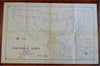
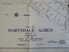
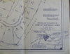
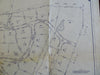
Map of Hartsdale Acres Situated at Hartsdale in the Town of Greenburgh Westchester County, N.Y.
(Old Maps, North America, United States, New York, Greenburgh, Hartsdale Acres, Development Map).
Issued 1929, Long Island City, New York by R.W. Hanson for the Corporation of Hartsdale Acres.
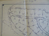
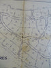
Early 20th century antique lithographed map depicting the lot lines of this proposed housing development.
Old fold lines. Old staining, wear down centerfold line with small loss, pen amendments to inset at lower right, short edge tears.
Undoubtedly uncommon/ scarce ephemeral survival of a map which was likely printed in small numbers and rarely saved.
Sheet Measures c. 39" H x 30 1/2" W.
Printed Area Measures c. 33" H x 28" W
[B6474].