Indian Ocean Southern Africa India Southeast Asia Currents 1856 information map
Brian DiMambro- Antiquarian Books, Maps & Prints
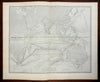
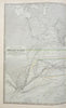
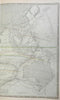
Physical Chart of the Indian Ocean Showing the Temperature of the Water, The Currents of the Air and Ocean, Directions of the Wind, Districts of Hurricanes, Regions of the Monsoons & Ty-Foons, Trade Routes.
(Indian Ocean, Africa, Asia, Australia, Southeast Asia, Indonesia, Malaysia, India, Trade Routes, Ocean Currents, Monsoons, Typhoons).
Issued 1856, Edinburgh by William Blackwood and Sons. Engraved by W & A.K. Johnston.
Detailed and lovely large mid 19th century color lithographed folio map with piano key border. Lengthy Explanation at bottom center, reference key to colors bottom left which includes steam packet ships identified by a small ship symbol. Wind directions shown by arrows as are travel routes and water flows.
Well preserved, nice looking example with pleasing age patina.
Original center fold as issued.
Sheet Measures c. 21 3/4" H x 27" W.
Engraved Area Measures c. 20" H x 24" W.
Cartographic Reference(s):
Tooley's Dictionary of Mapmakers, vol. 1.
[R24793].