Kingdom of Piedmont c. 1850 detailed topographical map Alessandria Genoa Savoy
Brian DiMambro- Antiquarian Books, Maps & Prints
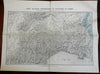

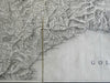

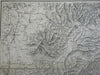
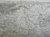
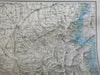
Carte Militaire Topographique et Strategique du Piemont par J.B.S. Raymond Capitaine au corps Royal des Ingenieurs- Geographes militaires.
(Europe, Italian Peninsula, Kingdom of Piedmont, Genoa, Savoy, Alessandria, First war of Italian Independence, fought against Austrians).
Issued c. 1850, Paris, Impr. by Villain. Map by J.B.S Raymond.
Mid-19th century folio sheet battle map focusing in on the key region during Italy's first war of Independence. This war resulted in Garibaldi's first defeat.
Scarce detailed French military topographical map with original hand color, dissected and backed on sturdy linen paper long ago.
Remains a nice looking example with a pleasing age patina, light minor surface dustiness or spot soiling. Any age flaws mostly minor and easy to overlook or forgive.
Sheet Measures c. 23 1/4" H x 31" W.
Engraved Area Measures c. 17 1/4" H x 23" W.
[R25452].