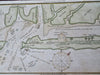
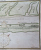
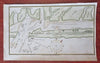
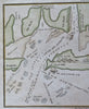
Little Egg Harbor New Jersey Tucker's Beach 1837 Blunt Hooker nautical map
Brian DiMambro
Untitled.
(Old Maps, 19thg Century Maps, Americana, North America, United States, New Jersey, Little Egg Harbor, Tucker's Beach, Nautical Maps, Coastal Surveys).
Issued 1837, New York by E. & G.W. Blunt. Map engraved by Hooker.
Charming little mid-19th century engraved nautical map with attractive hand color.
Remains a nice looking example with a pleasing age patina. Any age flaws mostly minor and easy to overlook or forgive.
Sheet Measures c. 5 1/2" H x 8 3/4" W.
Engraved Area Measures c. 5" H x 8 1/4" W.
Cartographic Reference(s):
Tooley's Dictionary of Mapmakers, vol. 1.
[B13566].