Messina Sicily Italy City & Harbor Plan c.1745 Basire large engraved battle map
Brian DiMambro
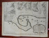
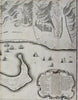
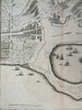


Plan of the Works of the City of Messina, One of the Strongest and Most Considerable Cities of Sicily and a Fine Sea-Port.
(Old Maps, 18th Century Maps, Europe, Italy, Sicily, Messina, Military Fortifications, Star Fort, City Plan, Sailing Ships, Harbor).
Issued c. 1745 London by Tindall. Engraved by J. Basire.
Mid 18th century detailed engraved city plan. Key within a scroll cartouche bottom right lists over 3 dozen specific locations within 3 columns. Numerous tall mast ships in the waters.
Nice looking example, pleasing age patina, any minor age flaws easy to overlook or forgive.
Original fold lines as issued.
Sheet measures c. 16" H x 19 1/2" W.
Engraved area measures c. 14 1/4" H x 18 1/2" W.
Cartographic Reference(s):.
Tooley's Dictionary of Mapmakers, vol. 1.
[R31911].