New South Wales Australia/ New Holland Norfolk Island 1794 Wilkinson scarce map
Brian DiMambro- Antiquarian Books, Maps & Prints
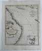
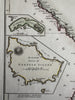
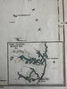

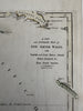
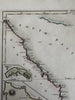
A new and accurate map of New South Wales with Norfolk and Lord Howe Islands from actual surveys. with three insets including Port Jackson, botany Bay and an accurate survey of Norfolk Island.
Uncommon late-18th century engraved map with original hand color.
A beautiful early map focusing on this part of eastern Australia. Three small insets.
Clean, fine condition, couple small indent dots or surface lines.
Sheet measures c. 10 1/2” W x 13 1/8”.
Printed area c. 9 1/4" W x 10 3/4".
R36268
Tooley, Mapping of Australia,