North America United States Canada Mexico Caribbean 1852 Mitchell map
Brian DiMambro- Antiquarian Books, Maps & Prints
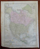
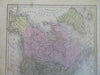
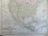
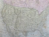
Map of North America.
(Old Maps, 19th Century Maps, North America, United States, Canada, Mexico, Caribbean Sea, Central America).
Issued 1852, Philadelphia by S. Augustus Mitchell. Map engraved by J.H. Young.
Mid 19th century engraved map with original hand color.
Overall light rubbing and dustiness, some scattered age spotting, still a relatively nice looking example with pleasing age patina worthy fo display.
Sheet Measures c. 9 1/4" x 11 1/2".
Engraved Area Measures c. 8 1/4" x 10 1/2".
Cartographic Reference(s):
Tooley's Dictionary of Mapmakers, vol. 3.
[R27418].