Northern Hemisphere 1816 Thomson map Mts. of Moon in Africa explorer tracks
Brian DiMambro- Antiquarian Books, Maps & Prints
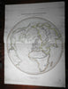
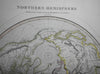
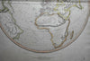
Northern Hemisphere Projected on the Plane of the Horizon of London.
(North America, South America, Europe, Africa, Asia, North Pole).
Issued Edinburgh, 1816 by Thomson.
Lovely early 19th century antique engraved map with original outline hand color.
Of note for the prominent huge unbroken chain of mountains depicted cutting across the entire middle interior, naming the apocryphal Mountains of the Moon and the supposed course of the Niger river. Tracks of Capt. Cook voyages seen across the oceans with dates. Interesting projection which alters the typical outline shape of the various continents.
Some old offsetting, light mostly minor stains of soiling in blank margins, overall the image is clean, well preserved and very attractive.
Original fold line as issued.
Sheet measures c. 21" x 28"
Engraved area measures c. 19" x 18"
[R21032]
Tooley's Dictionary of Mapmakers, v. 4, p. 271.