Ottoman Empire Arabia Persia Africa Emerald Mts. 1777 Bowen folio hand color map
Brian DiMambro- Antiquarian Books, Maps & Prints

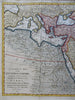

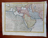
A Correct Map of the Ottoman Empire, Including All the Countries Possessed by, or Tributary to the Turks in Europe, Asia, & Africa, with Part of the Adjacent Territories, According to the Latest Observations.
(Old Maps, 18th century Maps, Asia, Ottoman Empire, Anatolia, Armenia, Caucasus, North Africa, Egypt, Arabia, Persia, Iran).
Issued 1777, London for Middleton. Map by Thomas Bowen.
Very nice 18th century engraved map with attractive hand color.
Splendid array of fantasy features seen within Africa, including wildly speculative mountains which includes "mountains where emeralds are found. Mogol Empire named at far right India.
Remains a nice looking example with a pleasing age patina. Any age flaws mostly minor and easy to overlook or forgive.
Original fold lines as issued, some typical extraneous fold lines as often found on these large sheets.
Sheet Measures c. 14 1/4" H x 18 1/2" W.
Engraved Area Measures c. 12 1/2" H x 16" W.
Cartographic Reference(s):
Tooley's Dictionary of Mapmakers, vol. 1.
[R29591].