Quebec Three Rivers New Brunswick Nova Scotia 1848 Cowperthwaite Mitchell map
Brian DiMambro- Antiquarian Books, Maps & Prints
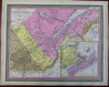
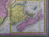
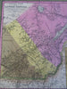
Canada East, Formerly Lower Canada.
(Old Maps, 19th Century Maps, North America, Canada, Lower Canada, Three Rivers, Quebec, Maritimes, New Brunswick, Nova Scotia, Prince Edward Island).
Issued 1848, Philadelphia by Cowperthwaite for S.A. Mitchell.
Lovely 19th century engraved and lithographed map with original hand color. Mitchell maps of this mid-century era were issued with a range of color as well as variant decorative borders.
Nice looking example, clean and fresh, pleasing age patina, any small age spots or minor age flaws easy to overlook or forgive.
Sheet Measures c. 12 1/2" H x 15 1/4" W.
Engraved Area Measures c. 10 1/2" H x 13 1/2" W.
Cartographic Reference(s):
Reps, American Maps and Mapmakers, p. 313.
Tooley's Dictionary of Mapmakers, vol. 4, pp. 260.
[R29738].