Republic of Chile Conception Santiago 1855 U.S. Astronomical Expedition map
Brian DiMambro- Antiquarian Books, Maps & Prints

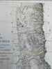

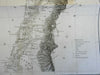
Sheet II - Map of the Republic of Chile. Compiled by the U.S. Astron. Expedition from the Surveys of Messrs. Pissis & Allan Campbell.
(South America, Republic of Chile, Conception, Santiago, Valparaiso, Talca)
Issued 1855, Washington by the U.S. Astronomical Expedition.
Mid 19th century lithographed map printed on thin paper. Key locates gold, silver and copper mines as well as proposed railroad lines.
Nice looking example, pleasing age patina, any minor age flaws easy to overlook or forgive.
Original fold lines as issued.
Sheet measures c. 18 3/8" H x 11 3/8" W.
Engraved area measures c. 16" H x 9 5/8" W.
Cartographic Reference(s):.
Tooley's Dictionary of Mapmakers, vol. 4.
[R24624].