Roermond Holland City Plan Guicciardini 1582 Plantin fine antique map hand color
Brian DiMambro- Antiquarian Books, Maps & Prints
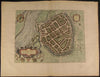
Ruremunda Gelriae Opp
issued Antwerp: 1582, Printed by Christophe Plantin for Guicciardini
Based on the plan by Braun & Hogenburg
A lovely and scarce 16th century plan of Roermond, Holland.
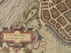
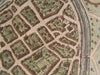
Shows the layout of city, with individual houses and buildings rendered complete with tiny doors and windows. Shows the fortifications and the city's moat, also shows the river and the city's surrounding geography including hills and plains. Also shows an area to the left of the fortified city, with additional individual houses and streets rendered.
Features a beautiful strapwork cartouche at lower left, and a coat of arms with a Lion.
Plantin was born in 1514 and died in 1589. Plantin left his native France for Belgium because of religious persecution. In Antwerp his work, at first as a bookbinder, began in 1549. He began the production and publishing of books as a printer in 1555. His establishment continued to work until 1867 and is now preserved as the Plantin-Moretus Museum in Antwerp. Plantin was the leading European printer of the second half of the 16th cent., and his books are admired for their accuracy and their typography. His equipment included types designed by Garamond and Granjon.
In VG to VG+ antiquarian condition, beautifully hand colored.
A pleasing example.
Sheet measures c. 17" W x 13" H;
image area c. 12 1/4" W x 9" H.
Deys, Guicciardini Illustratus, p. 320 (1.1)
Tooleys Dictionary of Mapmakers , vol..3 , p.442
R848