South Africa Egypt & Nile NW Africa coast 1895 Large hand color Bradley map
Brian DiMambro
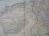
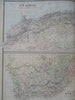
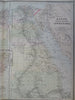
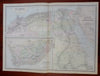
N.W. Africa - South Africa - Egypt, Arabia, Petra, and Lower Nubia.
(Old Maps, 19th Century Maps, Africa, Morocco, Algeria, Egypt, Sudan, Cape Colony, Boer Republics).
Issued 1895, Philadelphia by Bradley.
Late 19th century large hand colored folio sheet map.
Well preserved, nice looking example with pleasing age patina.
Original center fold as issued.
Sheet Measures c. 18 3/4" H x 25" W.
Printed Area Measures c. 17 1/4" H x 23 3/4" W.
Cartographic Reference(s):
Tooley's Dictionary of Mapmakers, vol. 1.
[R31933].