World Map on Mercator's Projection c. 1870 Jacobs large engraved map
Brian DiMambro- Antiquarian Books, Maps & Prints
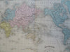
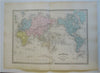
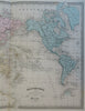
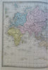
Mappe Monde Suivant la Projection de Mercator.
(Old Maps, 19th Century Maps, World Map, Mercator's Projection, Africa, Europe, Asia, Australia, Oceania, North America, South America).
Issued c. 1870, Paris by Fosset. Map by Fremin. Engraved by Jacobs.
Late 19th century engraved map with original hand color.
Well preserved, nice looking example with pleasing age patina.
Original center fold as issued.
Sheet Measures c. 15 1/2" H x 21" W.
Engraved Area Measures c. 11 1/2" H x 16 3/4" W.
Cartographic Reference(s):
Tooley's Dictionary of Mapmakers, vol. 4.
[R28152].