British India Qing Empire China Tibet Southeast Asia Hindostan 1867 Mitchell map
Brian DiMambro- Antiquarian Books, Maps & Prints
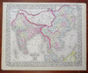
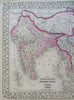
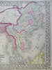
Map of Hindoostan, Farther India, China, and Tibet.
(Asia, Southeast Asia, India, British Raj, Malaysia, Cambodia, Siam, Thailand, Vietnam, Qing Empire, China, Tibet).
Issued 1867, Philadelphia by S.A. Mitchell.
Fine 19th century engraved (lithographed) map, with original hand color. Mitchell maps of this mid-century era were issued with a range of variant decorative borders.
Attractive example, pleasing age patina, overall clean, any minor age flaws easy to overlook or forgive.
Sheet Measures c. 15 1/4" H x 12 1/2" W.
Engraved Area Measures c. 13 3/4" H x 11 1/4" W.
Cartographic Reference(s):
Reps, American Maps and Mapmakers, p. 313.
Tooley's Dictionary of Mapmakers, vol. 4, pp. 260.
[R27264].