Holy Land Palestine Israel Jerusalem City Plan c. 1850 German detailed map
Brian DiMambro
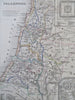
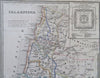

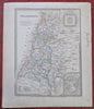
Palastina.
(Old Maps, 19th Century Maps, Asia, Middle East, Holy Land, Palestine, Israel, Jerusalem).
Issued c. 1850, Hildburghausen, Germany by the Bibliographic Institute.
Mid 19th century antique engraved map with original outline hand color.
Insets of a plan of Solomon's Temple and the old city of Jerusalem.
Well preserved, nice looking example with pleasing age patina, sheet uniformly age toned with minor light spotting mostly in blank margins.
Sheet Measures c. 11 3/4" H x 9 3/4" W.
Engraved Area Measures c. 9 3/4" H x 7 1/4" W.
Cartographic Reference(s):
Tooley's Dictionary of Mapmakers, vol. 1.
[R33641].