Isles of Shoals Smuttynose & Hog Islands New England Lighthouse 1873 coastal map
Brian DiMambro
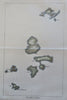
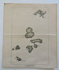
The Isles of Shoals.
(Old Maps, 19th Century Maps, North America, United States, New England, New Hampshire, Maine, Isles of Shoals, Hog Island, Smuttynose Island, Lighthouse).
Issued 1873, United States.
Late 19th century lithographed map with lovely hand color.
Original center fold as issued.
Sheet Measures c. 8 1/4" H x 7" W.
Printed Area Measures c. 7 1/2" H x 5" W.
[B13535].