Africa continent unique boundaries 1887 large scarce Bradley-Mitchell hc map
Brian DiMambro
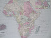
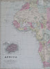
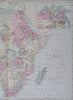
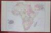
Africa.
(Old Maps, 19th Century Maps, Africa, Egypt, Nile Delta, St. Helena, Cape Colony, Guinea, Madagascar, Congo, Angola, Mozambique).
Issued 1887, Philadelphia by Bradley, successor to S.A. Mitchell.
Fine oversize late 19th century lithographed map, with original hand color.
This late Mitchell map was issued by Bradley for a short period before disappearing from publication. There are numerous variant issues, this one with a fascinating assortment of details not seen on earlier examples.
Attractive example, clean, pleasing age patina, any minor age flaws easy to overlook or forgive.
Centerfold as issued.
Sheet Measures c. 15 1/2" H x 25" W.
Engraved Area Measures c. 15 1/4" H x 22" W.
Cartographic Reference(s):
Reps, American Maps and Mapmakers, p. 313.
Tooley's Dictionary of Mapmakers, vol. 1 & vol. 4, pp. 260.
[R32527].