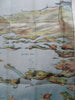
Boston Harbor & South Shore Provincetown c. 1910 folding panorama map
Brian DiMambro


(Old Maps, 19th Century Maps, Americana, New England, Massachusetts, Boston, Boston Harbor, Provincetown, South Shore, Steamboat Routes).
Bird's Eye View of Boston Harbor and South Shore to Provincetown, Showing Steamboat Routes.
Published c. 1900-20, Boston by John F. Murphy.
Folding color litho map panorama, still within the card stock folder. Text in English.
Item is over 100 years old and shows some signs of handling and time. Item is not new or in "new" condition.
Paper gently age worn, slight rubbing, remains overall clean and attractive as a fragile survival.
Paper is lightly toned, signs of handling, internally still well preserved, tight, sound.
Still attractive on the shelf. The item displays a pleasing and unique age patina and overall is in nice antiquarian condition, any age flaws easy to overlook or forgive.
Please review photos for more detail and our best attempt to convey how this offering survives.
Covers measures c. 8" H x 4" W.
[B9650].