British Isles Ireland England Wales Scotland London Edinburgh Dublin 1809 map
Brian DiMambro
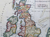
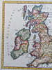
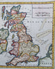
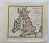
Isles Britanniques.
(Old Maps, 19th Century Maps, Europe, British Isles, Ireland, United Kingdom, England, Wales, Scotland, London, Edinburgh, Dublin, Cardiff).
Issued 1809, Paris.
Early 19th century engraved map with attractive hand color.
Remains a nice looking example with a pleasing age patina. Any age flaws mostly minor and easy to overlook or forgive.
Sheet Measures c. 8" H x 9 1/4" W.
Engraved Area Measures c. 6 1/4" H x 6 1/4" W.
[B13539].