British Isles Ireland United Kingdom 1850's Brue large detailed map hand color
Brian DiMambro- Antiquarian Books, Maps & Prints
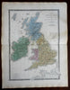
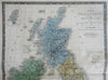
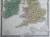
Iles Britanniques our Rouyaume-Uni de la Grande Bretagne et de L'Irelande.
(Europe, British Isles, Ireland, United Kingdom, England, Scotland, Wales).
Issued c. 1850-60's, Paris by A. Brue. [Delagrave].
Lovely and uncommon early 19th century folio sheet antique map. Engraved with original hand color, piano key border.
Longitude given from Paris.
Minor light offsetting, short edge tears at left wide blank margin (well outside map area), but overall clean and attractive.
Original fold line as issued. Nice heavy paper.
Sheet measures c. 19" x 24 1/2"
Engraved area measures c. 14" x 20"
[R25552]
Tooley's Dictionary of Mapmakers, v. 1, p. 199.