Cherbourg-Octeville France fortified military city plan 1758 map Cherburg
Brian DiMambro- Antiquarian Books, Maps & Prints
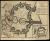

A Genuine Plan of Cherburg with the Forifications, as Intended to be Finished According to the Design of Mr Dr Caux.
(Europe / France / Cherbourg-Octeville / English Channel).
Issued 1758, London for Gentleman's Magazine.
Scarce mid-18th century British periodical map.
Nice looking example, pleasing age patina, any minor age flaws easy to overlook or forgive. Fold lines as issued.
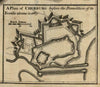
Includes inset of "A Plan of Cherburg Before the Demolition of its Fortifications in 1689".
Sheet measures c. 8 3/8"H x 10 1/4"W.
Engraved area measures c. 7 5/8"H x 9 7/8"W.
Cartographic Reference(s):.
Jolly, Maps in British Periodicals, GENT-119.
[R19985].