Eastern United States 1853 S. Hall large old map
Brian DiMambro- Antiquarian Books, Maps & Prints
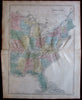
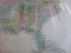
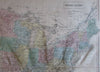
United States.
(Eastern North America).
Issued 1853, Edinburgh by A & C Black. Engraved by S. Hall.
Fine engraved map, with lovely original hand color.
A long centerfold split at left 4 1/2", closed 2" tear at left centerfold, still nice looking, noble visual appearance, any age flaws easy to overlook or forgive.
Sheet Measures c. 12 3/4"H x 17"W.
Engraved Area Measures c. 19 3/4"H x 14 3/8"W.
Cartographic Reference(s):
Tooley's Dictionary of Mapmakers, vol. 2.
[R19459].