Exodus Egypt Holy Land Mount Sinai Red Sea c. 1814-16 Bower pictorial map
Brian DiMambro- Antiquarian Books, Maps & Prints
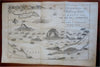
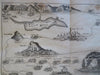
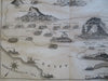
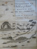
The Journeyings of the Children of Israel from Egypt Through the Red Sea and Wilderness to the Land of Canaan.
(Old Maps, 19th Century Maps, Asia, North Africa, Egypt, Red Sea, Holy Land, Canaan, Israel, Palestine, Mt. Sinai, Exodus, Moses).
Issued c. 1814-16, Philadelphia. Engraved by Bower.
Early 19th century pictorial map; perhaps an early ancestor of much later cartoon pictorial maps.
Nice looking example, pleasing age patina, any minor age flaws easy to overlook or forgive.
Original fold lines as issued.
Sheet measures c. 10 3/4" H x 16 1/4" W.
Engraved area measures c. 9 1/4" H x 14" W.
Cartographic Reference(s):.
Tooley's Dictionary of Mapmakers, vol. 1.
[R28891].