Mississippi & Louisiana states southern USA 1876 scarce U.K. made map
Brian DiMambro- Antiquarian Books, Maps & Prints
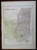
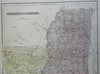
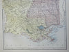
Mississippi & Louisiana.
(North America, United States, American South, Louisiana, Mississippi, New Orleans, Baton Rogue, Mobile, Jackson).
Issued 1876, Edinburgh by A. & C. Black.
Fine and uncommon late 19th Century color lithographed map. which also uses original hand color for the yellow and blue
Well preserved, nice looking example with pleasing age patina.
Sheet Measures c. 12 1/2" H x 17 1/2" W.
Engraved Area Measures c. 10 1/4" H x 14" W.
Cartographic Reference(s):
Tooley's Dictionary of Mapmakers, vol. 1.
[R25481].