New Zealand coast Mercury Bay Tolaga Capt. Cook 1797 large old engraved
Brian DiMambro- Antiquarian Books, Maps & Prints


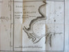
De Rivier de Theems en Mercurius Baai in Nieuw Zeeland
Eiland Baai in Nieuw Zeeland.
Baai Tolaga in Nieuw Zeeland.
(New Zealand- Pacific Ocean islands- Charts of the River Thames and Mercury Bay, Bay of Islands, Tolaga Bay in New Zealand)
Issued c.1797, Leiden by Honkoop, et. al. for a scarce Dutch version of Capt. Cook.
Fine 18th century antique engraved map.
Paper and image remains clean and well preserved with a fine patina and visual appeal.
Original fold lines as issued for a small 8vo edition of Capt. Cook's voyages.
Sheet measures c. 12"H x 18"W.
Printed area measures c. 10 3/4"H x 16 3/4"W.
Tooley's Dictionary of Mapmakers , vol. 2.
Beddie, Bibliography of Capt. Cook, p.159 (English version, London 1773).
[R16136]