South America Northern Part Brazil Peru Venezuela 1855 Stulpnagel detailed map
Brian DiMambro- Antiquarian Books, Maps & Prints
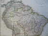
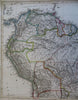
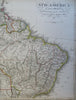
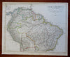
Sud-Amerika.
(Old Maps, 19th Century Maps, South America, Colombia, Venezuela, Ecuador, Peru, Brazil, Guyana, Bolivia).
Issued 1855 Gotha by Justus Perthes for Stieler. Map by Stulpnagel.
Nicely detailed oversize mid-19th century engraved map with original hand color.
This example has no centerfold, unlike most Stieler maps.
Stieler maps went through continual revisions. Thus, for any specific Stieler map such as this one, there are typically numerous variant issues with varying details.
Nice looking example, mostly clean, top right blank margin shaved narrow, pleasing age patina, any minor age flaws easy to overlook or forgive.
Sheet Measures c. 14 3/4" H x 17 1/2" W.
Cartographic Reference(s):
Tooley's Dictionary of Mapmakers, vol. 4.
[R29145].