Western & Southern Australia Kangaroo Island Perth Adelaide c. 1860 Weller map
Brian DiMambro- Antiquarian Books, Maps & Prints
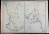

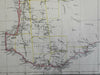

Western Australia & South Australia.
(Oceania, Australia, Western Australia, South Australia, Kangaroo Island, Adelaide, Perth).
Issued c. 1860, London by Day & Son. Map by E. Weller.
Fine antique lithographed map with original outline color.
Slight paper creasing across the center which is easy to overlook. Worthy of display.
Sheet Measures c. 19" H x 13" W.
Printed Area Measures c. 17" H x 12" W.
Cartographic Reference(s):
Tooley's Dictionary of Mapmakers, vol. 4.
Tooley, Mapping of Australia, 1325.
[PL5 - R2910].